|
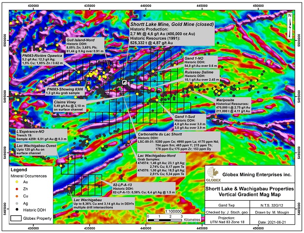
Shortt Lake Mine - Gold, Rare Earths
Gand Township, Quebec (NTS 32G/12)
Updated June 2021
Property
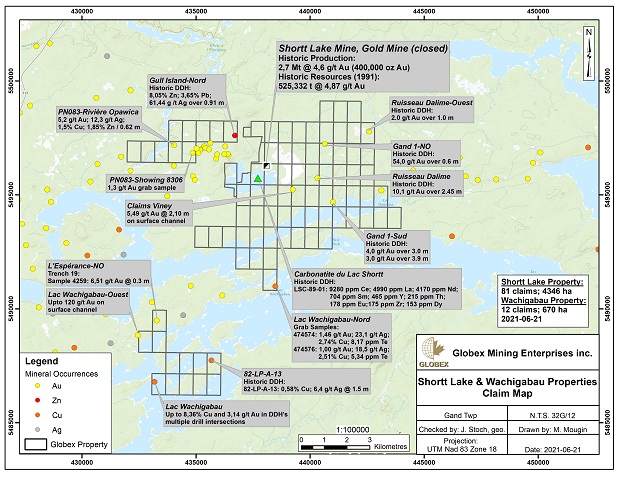
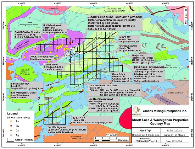
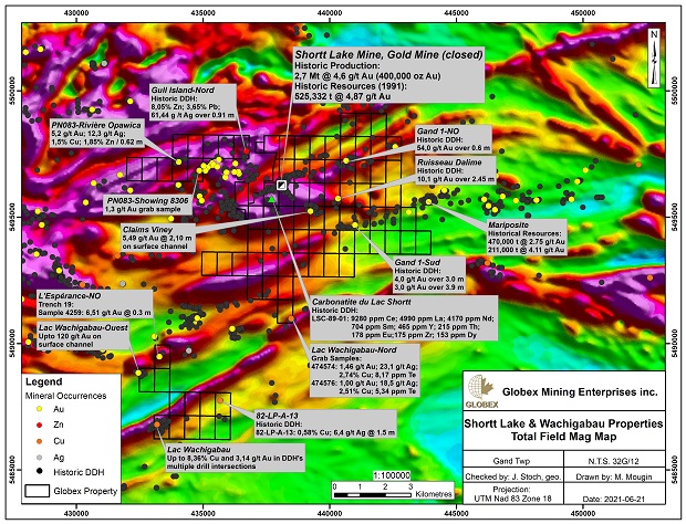
The property is located 75 miles (120 kilometres) southwest of the town of Chibougamau, Quebec, Canada. It consists of 81 claims, for 4,346 hectares, including the underground workings of the former Shortt Lake Gold Mine.
Ownership
Globex holds a 100 % interest in the claims.
Previous Work
In 1984, Falconbridge Copper started to mine the Lake Shortt gold deposit, replaced by Minnova in 1986 for 6 years. The production at the mine was 2.7 million tonnes grading 4.62 g/t gold (more than 390,000 ounces of gold).
Between 1986 and 1989, 4 drill holes identified a rare earth bearing carbonatite intrusion on the property but no work were made since this rare earth discovery.
Geology
(Information published by NQ Exploration on their website 2011 under authorisation)
The deposit is Archean in age, controlled by a steeply-dipping shear zone in a mafic rock setting. The ore consists of a pyritic mylonite resulting from deformation and replacement of a magnetic, syenite-injected gabbro in the footwall of the Shortt Lake regional fault. It is characterized by its close association with an alkaline carbonatite syenite complex that caused fenitization of the rocks in the area of the mine.
South Zone
The south zone corresponds to an alteration zone 30 to 60 metres thick, striking N080°/80°S. It extends from approximately mine coordinates 5000E to 5500E (NQ grid: 1000W to 500W), from the 400 to the 600-metre level, at about 4600N (300 metres south of the mine shaft, NQ grid: 0 00N). It shows gold enrichment, but the grades intersected are subeconomic, averaging 0.35 g/t Au over 50 metres at the 500-metre level. The zone was tested at depth, at the 650 and 900-metre levels, and once again returned subeconomic grades.
West Zone
In 1986, many holes were drilled to the west of the mine, to test the grades obtained by drilling in 1982. An exploration drift was driven on the 250 level to allow drilling at 25 and 50-metre spacings. Three mineralized zones were identified between the 100 and 500 levels, within an up to 150-metre thick alteration halo:
-
A mylonite at the contact of the Lac Shortt green mica schist
-
A mylonite 40 metres farther south
-
A zone injected with quartz veins.
These zones are marked by gold enrichment, albeit weak, with grades that are difficult to correlate, particularly in the zone injected with quartz veins. A minable reserve estimate (not 43-101 compliant) indicated a total of 148,000 tonnes grading 3.3 g/t Au.
Another assemblage of quartz veins named Vein A in the north wall of the 250-level exploration drift was drilled, but then abandoned due to a lack of continuity and low grades.
Another resource estimate was done to determine the mining potential using in-situ leaching. The study area was between coordinates 4375E and 4475E (NQ grid: 1675W and 1575W), over a depth of 100 m starting from the 250 level.The resource estimate was 568,000 tonnes at 1.09 g/t Au (not 43-101 compliant), at a cutoff grade of 5 g/t.
East Zone of the Mine
The eastern extension of the mine was tested over 750 meters. Drilling is said to have intersected a gold zone with a number of interesting grades, but with a potential lateral extension of 75 to 150 meters (around 6075E, NQ grid: 075E) over a vertical height of at least 400 meters:
-
82-51: 4.62 g/t Au over 7.6 m
-
LSS-83: 11.0 g/t Au over 2.5 m
-
LSS-100: 4.6 g/t Au over 2.9 m
Two other holes, LSS-112 and LSS-113, were drilled at depth on either side of the plunge. They were 200 meters apart, and intercepted the structure at a vertical depth of over 500 meters with grades of 5.5 g/t Au over 0.45 m (LSS-112) and 1.3 g/t Au over 1.4 m (LSS-113). There would be a potential of several hundred thousand tonnes grading in excess of 4.6 g/t Au. The setting corresponds to a breccia within an altered zone, with carbonate metasomatism dominating the hematite-alkali.
It should be noted that not all the drill logs were found, with the data for holes 82-51 and LSS-100 taken from old documents. These holes have not yet been located on the property maps.
Deposit Extension at Depth
The extension of the main zone of the mine was drilled under the 830 level. Many economic grades were intersected, but the zone tends to pinch out at depth. The western edge of the gabbro, also the western boundary of the deposit, dips 70° east, while the eastern edge remains subvertical. The resulting narrowing rapidly reduces the volume of ore per vertical meter.
Green Mica Schist Fault
Directly southeast of the Lac Shortt mine, along the Green Mica Schist fault, a series of holes was drilled to test the contact of the fault with the magnetic gabbros hosting the Lac Shortt deposit and the East zone. Many holes were drilled from the mine workings (250 level) and a few from surface. Surface hole LSS-102 returned a grade of 5.9 g/t Au over 1.0 m. Later holes drilled in the same area (LSS-114 to 116) also returned very interesting results.
Eastern Extension of the Green Mica Schist Fault
Hole LSS-117 intersected a grade of 5.2 g/t Au over 1.5 meters associated with the Green Mica Schist fault, about 1.3 kilometers east of the old mine. Only one other hole, Hole LSS-119, was drilled in this area, 150 meters farther east, but failed to intersect a gold zone. This target has not yet been fully investigated.
North Fault
A fault was interpreted about 500 m north of and subparallel to the Shortt Lake fault. Called the North Fault, it was tested by a small number of holes (4-5), with a grade of 9.84 g/t Au over 1.05 m obtained in Hole LSS-73. Another hole drilled nearby (about 50 m west) only intersected 1.02 g/t Au over 4.06 m. This area merits more in-depth investigation.
Conclusion
In June and July 2011, NQ Exploration drilled three holes totalling 993 meters on the property
The third hole was drilled to test a structure interpreted from a MegaTEM survey in the southeastern part of the property. It intersected two strong gold zones, with the first grading 6.40 g/t Au over 1.20 meters from 61.0 to 62.2 meters, and the second grading 11.55 g/t Au over 1.30 meters from 242.0 to 243.3 meters. In both cases, the gold mineralization is associated with zones of quartz veinlets injected into a sheared, carbonatized and weakly hematized mafic volcanic with 4-6% disseminated pyrite.
The gold-bearing structures lie under the tailings pond of the old mine, in an underexplored area of the property. Assuming a similar orientation to that of the old mine, these zones could be unexplored for at least 700 meters along strike. They remain open both toward surface and at depth. A winter drilling program will be proposed in the near future.
|