|
Dalhousie - Copper, Nickel Optioned
Bourbaux & Berthiaume Townships, Quebec (NTS 32F/10)
Updated December 2017
Summary
The Dalhousie property contains 32 claims and is located 53km ESE of the town of Matagami in SNRC 32F10. The property is underlain by the layered intrusive Bell River Complex which on its western end is responsible for the Matagami mining camp. The eastern end of the complex, has seen much less attention. Most all the work occurred between 1956 and 1969, where the focus was drilling input conductors. Sulphide horizons, located in the ultramafic units of the layered complex, tend to have low Cu-Ni values, less than 1% Cu and 0.5% Ni, respectively. However, work in 2007 has shown there is untested copper potential in zones of limited to no conductivity. Specifically, Beep-Mat prospecting returning copper values up to 4.5% in grab samples. The 2007 exploration program also located 6 untested conductors, one of which is where the 4.5% Cu grab sample was obtained. Also of note is the lack of attentions paid to PGE’s, even though the mineralization is magmatic Cu-Ni.
Location – Access – Claim Description
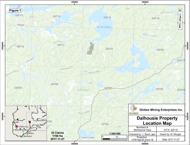
The Dalhousie property is located 53km ESE of Matagami Quebec and 4km South of Ramsay Bay at Lac au Goeland, SNRC 32F10 (Figure 1). Access is possible from either Matagami or Lebel-Sur-Quevillon, 70 km to the south. The property consists of 32 contiguous cells 100% owned by Globex Mining (1,786 Ha).
Geology
The layered intrusive Bell River Complex is located along the north central margin of the Abitibi Orogenic Belt (Figure 2). It is one of 3 layered igneous complexes within the belt that also include the Lac Dore Complex of Chibougamau and the Kamiskotia Complex near Timmins, Ontario. All three of these complexes have produced important mining camps.
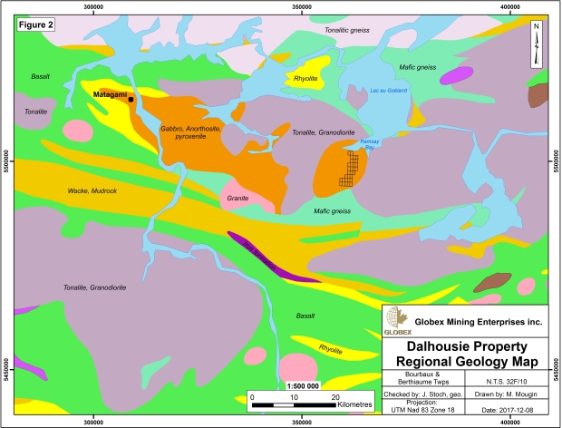
The Bell River Complex is divided into two lobes separated by the Lac Olga tonalite. Volcanic rocks north and south of the complex merge into one belt in the west, while in the east they are truncated by granitic intrusions.
Rocks underlying the property are generally layers of anorthosite - gabbro - pyroxenite and locally dunite (Figure 3). Mineralized horizons are typically found in the most mafic units but recent prospecting shows they can be found disseminated almost anywhere mafic minerals are present. Of interest is a Proterozoic dyke trending NE across the property that has an associated, offset magnetic high coincident with an untested conductor.
Work History and Mineralization
Work in the region was not continuous, but rather occurred in pulses. The first one was in the mid 1950’s to 1960’s. The second pulse was in the late 1980’s with Inco Ltd and the final pulse was in 2004 to 2007, with Explorateurs-Innovateures de Quebec (Ex-In) and Freewest Resources.
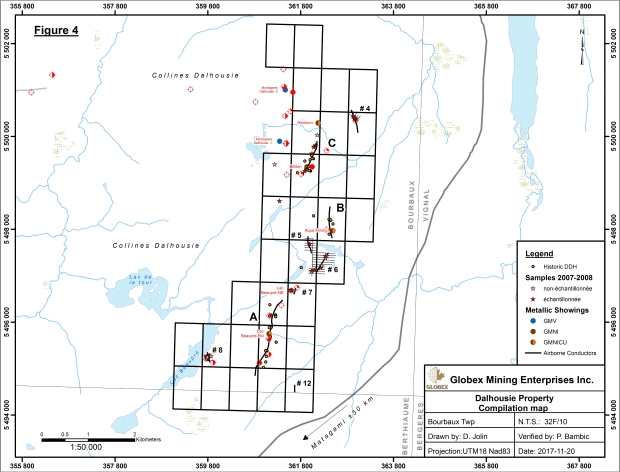
The first pulse of exploration between 1956 and 1969, was when the bulk of the work was done. A total of 36 holes were drilled by 7 companies resulting in the discovery of 4 mineral showings located in Areas A, B and C (Figure 4). Two additional showings were discovered by Ex-In with Beep-Mat prospecting between 2004 and 2007. A Beep-Mat is a geophysical device that can probe approximately 2m of overburden. These showing appear to be Cu-Ni sulphides stratabound to ultramafic horizons. Sulphide horizons encountered range from 50cm to 94m wide and can be traced as conductive bodies that extended to over 1.5km. However, Beep-Mat prospecting has identified another type of mineralization, disseminated copper rich horizons in non-ultramafic units. Several chalcopyrite zones were discovered not coincident with conductors. More work is required to determine the nature of this mineralization.
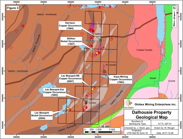
A brief summary of the mineralised zones found on the property are listed below starting from Harrison Showing in the north to Lac Beaupre Showing in the south. Note that up to 1987, no assays of gold, PGE’s or cobalt were reported.
Lac Beaupre-Est showing is located in Area A on a conductor that is 1.5km long. Sulphide intercepts range from 6 to 42m wide. The drill hole with 42m of sulphide (69M-2), was stopped in mineralization at 117m depth and had an average grade of 0.24% Cu and 0.11% Ni, including 14.3m of 0.42% Cu and 0.19% Ni. Other notable intercepts are: DDH hole 77730 of 1.85% Cu over 1.1m; DDH hole 69M-1 of 0.45% Cu and 0.24% Ni over 13.3m; DDH hole 69M-3 of 0.57% Cu and 0.88% Ni over 3.1m; DDH hole 7 of 0.34% Cu and 0.49% Ni over 8.2m.
Aqua Mining, showing occurs in Area A and B. In Area A it is located at the northern end of a 1.5km long conductor that also contains the Lac Beaupre-East showing. The best intersection here is was in hole #3A with 0.50% Cu and 0.48% Ni over 6.5m. In Area B, the best intersection was in hole #5 with 0.70% Cu and 0.50% Ni over 0.9m.
Harrison, showing is located in the northern region of Area C: Best drill intersections are: Hole 1 with 7.32% Cu and 0.34% Ni over 0.5m and 0.50% Cu and 0.34% Ni over 4m. This hole intersected 3 bands of variably mineralized sulphide of 15m, 8m and 9m thickness. Not all sulphide zones were sampled and no attention was paid to PGE’s. The Harrison showing is located at the north end of an 800m long conductor whereas the Billiton showing is at the south end. The middle of the conductor appears not to have been drilled.
Billiton showing located in Area C at the south end the of the Harrison conductor. The best drill intersection is hole 3 with 0.50% Cu and 0.34% Ni over 0.85m.
Lac Beaupre-NE showing was discovered by Beep-Mat prospecting in 2007. This location contains 2 conductors discovered at different times. The first being 2 Inputs (Questor Surveys) and a second a helicopter borne Time Domain Electromagnetic survey (TDEM). Only 1 grab sample was taken here which grades 1.60% Cu and 0.50% Ni. The Input and TDEM conductors have never been drilled.
Lac Beaupre has 2 Input anomalies that appear never to have been prospected until 2004 when Ex-In used a Beep-Mat to locate mineralization. A TDEM conductor in that location that extends for a length of approximately 300m. Best grab samples are 0.44% Cu and 0.87% Ni. The Input and TDEM conductors have never been drilled.
The next phase of exploration on the property was conducted by Inco in 1987. They compiled all previous work and ground truthed previously located conductors as well as prospected the areas of Input anomalies. In 1989 they drilled 4 holes, but managed to explain the conductor in only 1 of them. The last hole, # 77730 was drilled into the Lac Beaupre-Est showing (see above) and intersected 94m of mineralization. They assayed almost the entire length of mineralization for Cu, Ni, Au and PGE’s. A total of 121 samples were sent for Cu-Ni assaying and 972 for Au, PGE’s. However, grades were low: 16 samples returned over 0.30% Cu and 6 over 0.30% Ni. The best Cu – Ni intercept was in hole # 77730: 1.85% Cu over 1.1m and 0.82% Ni over 1.1m, in separate samples. The best PGE values were 6 samples that graded between 50 to 90ppb Au or PGE’s, in drill hole # 77727.
In 2004, En-Ix performed Beep-Mat prospecting over some of the known conductors and located what is now the Lac Beaupre and Lac Beaupre NE showings. Freewest Resources subsequently optioned the ground and performed a property wide airborne Mag-EM (TDEM) survey, with lines spaced 140m apart. This work helped to identify 12 previously unknown conductors, 6 of which are on Globex claims: # 4 to 8 and 12 (See Figure 4). The known conductors in Figure 4 are identified as Zones A, B and C. This is where the historic drilling cited above was focused.
It is important to note that none of these 6 new conductors located by TDEM have been drill tested, even though 3 of them coincide with Input anomalies (#4, 7 and 8). Conductors # 4, 5, 6 and 8 had small grids cut on top of them and were surveyed with Beep-Mat and Max-Min (50m cable, 25m penetration). Conductor # 7 was only Beep-Mat prospected and # 12 has never been visited.
The following are details of conductors 4 to 8 and comments on # 12:
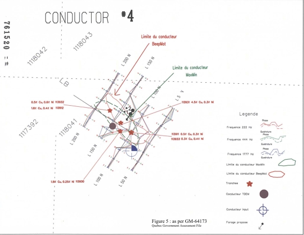
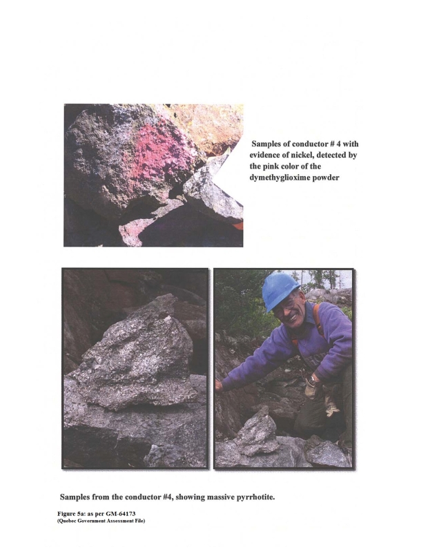
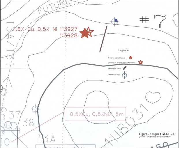
Conductor 4 (Figure 5). This TDEM conductor occurs only on 1 line, but is strong and although it contains a 3 channel Input conductor on mineralized Zone C, it has never been drilled. A grid of 4 lines 50m apart was established over this TDEM-Input anomaly, then surveyed with Beep-Mat and Max-Min(50m cable). Figure 5 shows that the outline of mineralization from both Max-Min and Beep-Mat, do not coincide. This is possibly a result of the Beep-Mat tracing the conductor at the surface and the Max-Min tracing it at a 25m depth. If this is true, the offset could be suggesting a dip for the body to the SW. Four conductive areas were stripped and blasted to expose mineralization. Unfortunately only 6 samples are recorded to have been taken. The highest copper value obtained on the surface was 4.5% Cu in sample # 113931 and the highest nickel was 0.57% Ni in sample # 113932 (Figure 5a). The quality of the conductor and fact that it was identified by the Input survey, suggest a strongly mineralized body. This conductor is coincident with a magnetic high and is also intimately associated with a diabase dyke. In order to properly drill this target, a deeper penetrating ground EM survey will be needed.
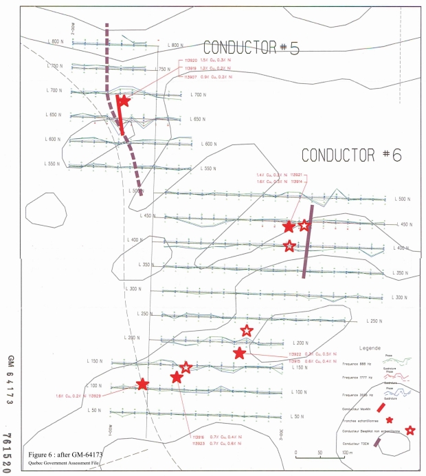
Conductors 5 and 6 (Figure 6). These conductors are moderate to weak in strength (5 and 6 respectively) and are located between the mineral zones A and B. A grid of 16 lines, 50m apart was cut over these conductors and extended to the south where there is a weak TDEM response. Conductor # 5 also coincides with a Max-Min anomaly. Of the 10 Beep-Mat anomalies sampled in this region, 5 of them assay over 1% Cu: 2 of them occur in Conductor 5 (1.5% Cu and 1.2% Cu); 2 of them in Conductor 6 (1.6% Cu and 1.4% Cu); and one at the weak TDEM anomaly (1.6% Cu). It is interesting to note that when Cu is high, Ni is low. The highest Ni values come from samples with lower Cu: 0.6% Ni and 0.5% Ni in the weak TDEM area. In order to drill test Conductor 5 and 6, deeper penetrating ground EM should be used to first define the quality of the conductor. In order to properly drill define the weak TDEM area, IP would be needed.
Conductor 7 (Figure 7). It does not appear as strong as # 6, but is associated with a 3 channel Input conductor. The Beep-Mat outlined an anomalous area 40m N-S by 10m E-W and 1 grab sample was taken. It graded 1.6% Cu and 0.5% Ni. The weak conductor may mean the body is not close to surface or that the mineralization is stringer or disseminated so conductivity is weak. Drilling would be suggested, contingent on the drill results from Conductor 5 and 6 immediately to the north. Again, deeper penetrating ground EM and/or IP surveys would be needed to better define a drill target.
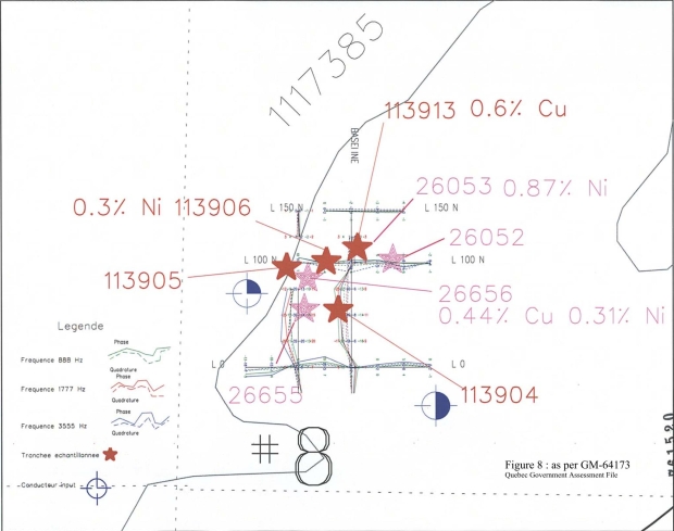
Conductor 8 (Figure 8). This conductor is strong and has been detected on 2 TDEM flight lines at 140m spacing and is coincident with 2 Input anomalies (3 and 4 channel). A small grid was cut on top of these conductors and a Max-Min survey was conducted. A total of 8 grab samples were taken with the highest values returning 0.56% Cu in sample #113913 and 0.87% Ni in sample #26053. Though the assay results are moderate, the conductors are strong and the body may be at least 200m wide. Metallic bodies are often zoned and a sampling from deeper in this stronger conductor, could yield much better results.
Conductor 12 (Figure 4). This is a weak, single line conductor like # 6 and 7, but that does not mean it is not significant. It could be top of a larger body at depth, thus generating a week response. It should be probed with deep penetrating EM.
Globex work
In 2015 Globex staked the property and performed a compilation in preparation for field work. It was decided in the fall of 2015 to perform an airborne survey over the property using a high a density gradient magnetic system in order to produce detailed magnetic maps that show fine structures. The system chosen was arrayed with 4 magnetic sensors: 2 in the vertical plane with a separation of 2.9m and 2 in the horizontal plane having a separation of 10m. Lines were flown N118°E, 75m apart and 40m above the ground.
As an additional benefit, this particular system also had 2 VLF receivers. It was decided that Cutler Maine (24.0kHz) and La Moure North Dakota (25.2 kHz) were the best stations to use.
The results of using 4 magnetic sensors with this particular geometry and flying tight lines close to the ground, is shown in Figure 9: a magnetic tilt derivative map, showing discrete structures. Inspection of this map shows that conductors 4 to 8 are all located on magnetic highs. The historical areas of drilling, A-B-C in Figure 4, are also located on discrete magnetic highs. Because of the coincidence of conductors and magnetism, one can easily speculate that all the discrete magnetic structures should be prospected, conductive or not. Conductivity requires a mass of connected sulphides. A disseminated zone of pyrrhotite could conceivably be magnetic but not conductive.
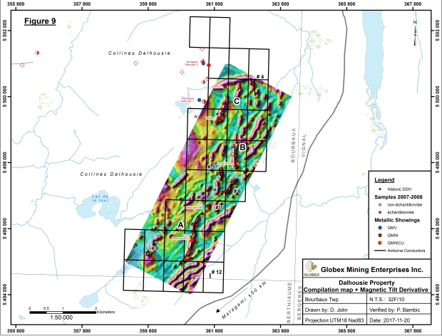
Magnetism typically shows geology, so these discrete structures are also showing mafic and ultramafic horizons. All the drilling and prospecting so far has shown a close association of ultramafic rocks and mineralization on the property. This is yet another reason to prospect all these discrete magnetic structures.
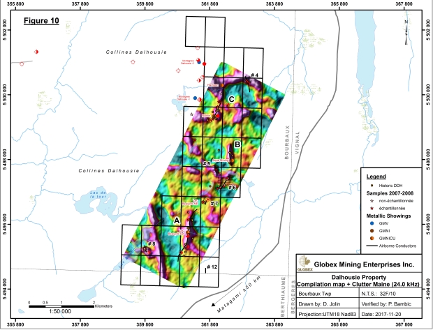
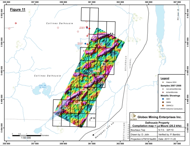
Figure 10 and 11 are VLF maps that show the response to Cutler Maine and La Moure North Dakota, respectively. The Cutler Maine map, Figure 10, shows the historic drilling in areas A-B-C, coincide for the most part with the AEM conductors of Figure 4. The VLF anomaly in the North, is showing the effects of the Proterozoic diabase dyke. The large, almost N-S trending anomaly in the South, could be outlining a major fault. These targets should also be prospected. However Figure 11, the VLF signal from La Moure North Dakota, seems to be mapping out lakes and streams. Note how Lac Beaupre and the streams and lakes extending out NNE of it, are locations of VLF highs.
Conclusion
The Bell River Complex is located along the north margin of the Abitibi Orogenic Belt. This northern location is also shared with 2 other famous layered complexes that have produced mining camps: the Lac Dore Complex in Chibougamau and the Kamiskotia Complex near Timmins, Ontario. Compared to the western portion of the Bell River Complex, the eastern end has had only one significant period of exploration that lasted from 1956 to 1969. Inco briefly worked the area but was only able to explain one conductor. In 2007 Freewest Resources located 6 new conductors but a follow-up drill program never occurred because markets collapsed in 2008 and no money was available. Globex acquired the ground in 2015 and performed a modern airborne survey that helps to explain some anomalies and generate ideas on others.
Current ideas would state that because the Dalhousie property has low Cu-Ni-PGE and gold values, there is only a limited potential in the area. If that were the guiding principal, in Thompson Manitoba, the mine would never have been found. At Thompson, an 8km long folded pyrrhotite body, usually grades about 0.1% nickel, yet all the rich lenses are found at depth in this conductive body. They persisted. Also, consider Voisey’s Bay. All the other historical conductors in the region were barren.
One need only to look at the Windfall deposit currently being developed by Osisko Mining, to remind us that mines are made, not found. The Windfall region had been worked on and off since the 1950’s. It took a new interpretation to understand how to explore.
Metallic bodies are zoned. The Dalhousie property is part of the Bell River layered complex, that hosts several mines in its western end. More work in required in the eastern end.
The Dalhousie property currently has 6 untested conductors that need to be tested. As well, the new geophysical survey Globex performed has generated other targets. In summary the following is proposed:
Conductor 4: A strong, one line TDEM with coincident 3 channel Input conductor, slightly offset from a diabase dyke. Prospecting returned 4.5% Cu, comes from this conductor. This target needs a deep penetrating ground EM surveys to define the center of mass and an IP survey to outline a potentially economic disseminated sulphide envelope, followed by drilling.
Conductor 5 and 6: Weak conductors that appear to be part of the main trend of Zone A–B–C. Though the conductors are weak, half the copper assays are above 1% Cu. A weak conductor could mean the body is deep or the metallic body in not well connected (stringer or disseminated). An interesting feature of this area is the wide disseminated zone just south of Conductor 6. It is possible that weak Conductor 5 and 6 indicate a large zone of disseminated sulphides with only minor lenses of massive sulphide. This sector should be tested with an IP survey and follow up drilling.
Conductor 7: A weak TDEM anomaly that also coincides with a 3 channel Input anomaly. This conductor is not strong but the presence of an Input anomaly, in an intrusive rock, indicates there is likely a metallic body present. If Conductors 5 and 6 are to be worked, then it is logical to extend the grid down to # 7 and survey this area as well.
Conductor 8: A strong conductor, occurring on 2 flight lines that also coincides with 2 Input anomalies (3 and 4 channel). This area appears off the main trend that is Zone A-B-C, and could therefore be different. A deep penetrating ground EM and an IP survey should be undertaken followed by drilling.
Conductor 12: Little is known other than it is a weak one-line TDEM anomaly. As mentioned above, a weak conductor, may be a result of its source being buried deep. To know more about this anomaly a deep penetrating ground EM survey is necessary.
The airborne Mag-VLF survey that Globex had done appears to have generated several more targets. The high definition magnetic tilt derivative map, clearly shows that conductors 4 to 8 are all located on discrete structures. Because of the coincidence of conductors and magnetism, all the discrete magnetic structures should be prospected, conductive or not.
While all the historical work on the property has been focused on defining airborne conductors, it is worth noting that copper/nickel deposits also occur as disseminated and/or stringer sulphides, the large Dumont nickel body in Quebec is a good example. Exploration should be directed toward all types of sulphide mineralization, massive, stringer and disseminated something that was never considered before. The Beep Mat surveys have located copper and nickel bearing sulphides near surface that are not related to airborne conductors. Lastly an initial observation suggests that copper values are higher in areas of disseminated mineralization located by the shallow penetrating Beep Mat surveys, again suggesting that disseminated sulphides are an important exploration target.
|