|
Victoria West Property - Gold
Cléricy Township, Quebec (NTS 32D/07)
Ownership
Globex owns 100% interest in the property subject to a 1% NSR due to underlying vendors.
Property
The property consists of 20 surveyed claims in ranges 9 (lots 24 to 38) and 10 (lots 27 to 30), totalling 766 hectares in Clericy township, Quebec.
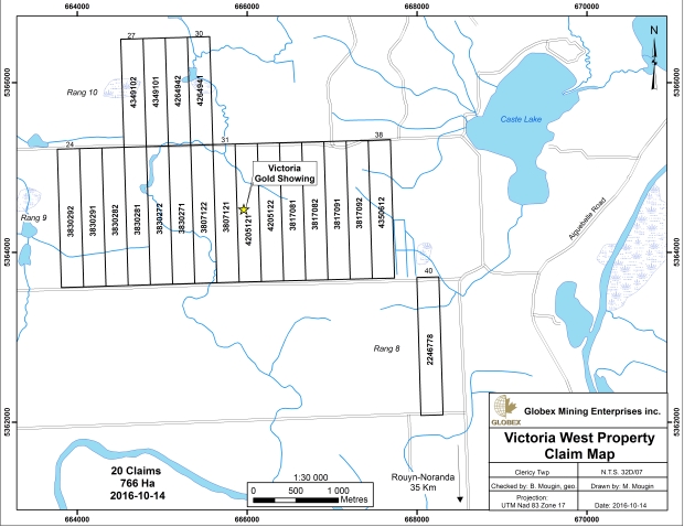
Access
The property is situated approximately 27 km north-east of the town of Rouyn-Noranda and about 6 km north of the hamlet of Mont-Brun. A gravel all weather range road (range 9/10) traverses the property.

Property
The property consists of 20 surveyed claims in ranges 9 (lots 24 to 38) and 10 (lots 27 to 30), totalling 766 hectares in Clericy township, Quebec.
Access
The property is situated approximately 27 km north-east of the town of Rouyn-Noranda and about 6 km north of the hamlet of Mont-Brun. A gravel all weather range road (range 9/10) traverses the property.
Previous Work
1918
Mapping by M.E.Wilson
1924
Mapping by W.E.James and J.B. Maudsley
1926
Richburn Mining, discovery of lot 32, range 9 gold showing
1928-1929
Star Gold Mines drilled six holes on lot 32 gold showing
1938-1939
Mapping by J.B.Ambrose
1947
Leric Mines Ltd. Drilled 3 holes totalling 439 metres. Holes 2 and 3 tested the extension of the now named Victoria gold showing.
1949
Leric Mines Ltd. drilled 4 holes totalling 245 metres. Intense zone of carbonate and pyrite found within a talc-chlorite zone over 21.3 metres. All the drill holes intersected gold values the best being 2.46 g/t Au over 9.5 metres.
1952
Victoria Copper Zinc Mines drilled 5 holes totalling 400 metres to test the showing to the west and to depth. The best intersections were 3.08g/t Au over 6 metres 1.78 g/t Au over 15 metres and .91 g/t Au over 6 metres. The zone was defined over a strike length of 70 metres to a depth of 60 metres.
1956
Alba Exploration - electromagnetic and magnetic surveys and 3 drill holes totalling 360 metres. Four conductors located.
1980
Kerr Addison Mines Ltd., entire property covered by magnetometer and I.P. surveys. Three drill holes totalling 504 metres were drilled at the Victoria showing.
1987
Fairfield Exploration, survey of old drill holes and old trenches. Sampling of trenches.
1988
Fairfield Exploration, Mag., EM. and I.P. surveys in the area of the Victoria gold showing.
Drilled 3 holes totalling 288 metres on weak EM and I.P. anomalies.
1994
Santa Fe Canadian Mining - reinterpretation of existing geophysical surveys, new magnetic survey, mapping and sampling as well as 2178 metres of drilling.
1996
Globex Mining Enterprises Inc., magnetic and I.P. survey on range 10 claims. Two drill holes completed.
1997
Maude Lake Exploration Ltd., 30 km grid covering Victoria showing and surrounding area. Magnetic and Real Section I.P. surveys. Seven drill holes totalling 1707 metres were drilled, six on the Victoria gold showing extension area and one on a geological/geophysical target in the north-east of the property. The best results were from hole 97-1 (1.3 g/t Au over 14.5 metres including 3.1 g/ t Au over 3.5 metres) and hole 97-6 (2.22 g/t Au over 0.5 metres). The drill program was followed by mapping.
Regional Geology
The property is situated in the central-south part of the Abitibi Greenstone Belt. Two rock groups are typical of the area.
(1) To the north, mafic to ultramafic flows and volcanoclastics of the Malartic Group.
(2) To the south-west sediments of the Kewagama Group.
The north-west/south-east trending contact of those two groups is also the trace of a southward trending branch of the Porcupine-Destor break.
Local Geology
At the centre of the property one finds a sequence of Malartic Group mafic flows oriented E-W to WNW-ESE. These rocks are on average pale green and are non magnetic. The flows are often pillowed but massive or brecciated flows are also found on the property. To the south, pillows indicate tops to the south-west.
Ultramafic flows interfinger with the mafic flows. These are generally massive and in some cases brecciated, talcose and strongly magnetic. Near the Victoria gold showing these ultramafic flows are non-magnetic and display an intense green carbonate (Fe-Mg-Ca carbonate ± fuschite ± sericite) alteration. Some relic spinifex and polygional jointing is preserved.
Sedimentary units of the Kewagana Group outcrop in the south part of lots 28 and 29.
Numerous dykes (1 to 10 metres wide) of quartz-feldspar porphyry composition cut the volcanic units.
At the north end of the property (range 10) a rose granite outcrops. It is traversed by numerous 1 to 5 cm wide quartz veins. Wide zones of fuschitic carbonate occur on the next lot east of the range 10 claims.
The principle schistosity is well developed in a 280o to 300o direction with dips near vertical.
The Victoria gold showing is the only significantly mineralized and altered area on the property found to date. The showing is principally iron carbonates and fuschite cut by quartz-tourmaline veins. The rocks are foliated and sheared at 280o to 300o.The mineralization is in mafic flows in the form of lenses in the iron-carbonate and fuschitic altered komatites. The flows are folicated at 250o to 280o with a steep northern dip.
Numerous quartz-carbonate veins are present in the basalts and altered komatites. They vary from several millimetres to many metres in width. Fine grained pyrite and traces of chalcopyrite are often present in quantities of up to 3%.
The property is adjacent to Typhoon Exploration Inc’s Fayolle property to the west, which hosts a gold deposit of the same home. The Fayolle gold deposit has indicated resources of 106,900 tonnes at 6.4 g/t Au and inferred resources of 218,000 tonnes at 6.39 g/t Au (using a 3 g/t Au cut off grade).
Conclusion
The property is located on a southern splay of the gold localizing Porcupine-Destor Fault. Wide zones of intense alteration and low grade gold mineralization have been found at the centre of the largely overburden covered property. Further exploration is warranted.
|