Geological Setting
The reader is directed to the 2011 Annual Information Form for details concerning the regional and local geological features of the Kipawa Alkaline Complex (K.A.C.) underlying the Property.
Extensive exploration work by Matamec Explorations Inc. over the past several years on its Kipawa rare earths deposit located 8.5 km southwest of Globex’s Turner Falls property was outlined, on October 21, 2013, in a press release issued by Matemac indicating that the filing of the first NI 43-101 feasibility study for this heavy rare earth project represented an important milestone for the Company and the rare earth industry. A technical report, titled ”Feasibility Study for the Kipawa Project, Temiscamingue Area, Québec, Canada” was issued on October 17, 2013, with an effective date of September 4, 2013, by Roche Ltd, Consulting-Group in collaboration with Genivar, Golder and Associates, SGS Canada Inc. and filed on October 21, 2013 on SEDAR at (www.sedar.com) and on Matamec’s website at (www.matamec.com). Matemac Explorations inc. is a Canadian Issuer.
The technical report includes a reference (ref: page 151, Table 15.5) to “In-Pit” mineral reserves of proven and probable reserves of 19.769 Mt grading 0.4105% TREO, (mining/milling dilution included) and where TREO equals the total of rare earth oxides calculated as: LREO (%) + HREO (%) + Y2O3 (%).
|
In-Pit Mineral Reserves
|
Metric Tonnes
|
|
Proven (51.7% of the deposit)
|
10,219,000
|
|
Probable (48.3% of the deposit)
|
9,550,000
|
|
Total
|
19,769,000
|
|
Total Grade
|
|
Cerium (Ce2O3)
|
0.1195
|
|
Lanthanum (La2O3)
|
0.0588
|
|
Praseodymium (Pr6O11)
|
0.0146
|
|
Neodymium (Nd2O3)
|
0.0550
|
|
Samarium (Sm2O3)
|
0.0123
|
|
Europium (Eu2O3)
|
0.0015
|
|
Gadolinium (Gd2O3)
|
0.0119
|
|
Terbium (Tb4O7)
|
0.0022
|
|
Dysprosium (Dy2O3)
|
0.0147
|
|
Holmium (Ho2O3)
|
0.0032
|
|
Erbium (Er2O3)
|
0.0101
|
|
Thulium (Tm2O3)
|
0.0016
|
|
Ytterbium (Yb2O3)
|
0.0096
|
|
Lutetium (Lu2O3)
|
0.0013
|
|
Yttrium (Y2O3)
|
0.0943
|
|
TREO
|
0.4105
|
The technical information has been reviewed by a qualified person for Globex. To the best of Globex’s knowledge, information and belief, there is no new material scientific or technical information that would make the disclosure of this feasibility study, mineral resources, or mineral reserves inaccurate or misleading.
Globex has included this information as it considers the Turner Falls property to be an adjacent property and therefore provides contextual information for reviewing Globex’s exploration results as described below.
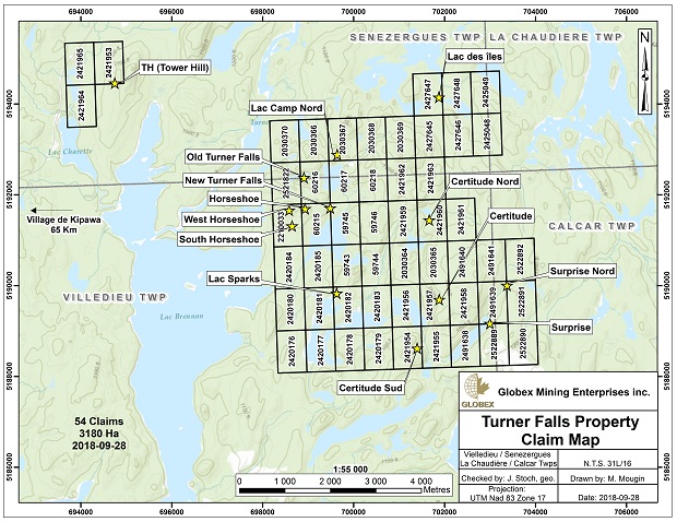
Exploration
Globex acquired the Turner Falls property by staking in 2007 and began fieldwork in 2009.
Initial prospecting and cursory scintillometer checks in 2009 were followed by 20 line-km of east-west grid line cutting to enable a more systematic ground magnetometer and scintillometer coverage at 100 metre line spacing. Geological mapping, rock sampling and limited trenching were also carried out in that year. This work led to the discovery of several new rare earth showings including the New Turner Falls Showings where highly anomalous values in the light rare earths including lanthanum (up to 0.498%), cerium (up to 1.28%), praseodymium (up to 0.144%), neodymium (up to 0.44%) and samarium (up to 0.145%) as well as heavy rare earth values including europium (up to 73 ppm), gadolinium ( up to 0.1260%), terbium ( up to 263 ppm), dysprosium (up to 0.177%), erbium (up to 0.115%), thulium (up to 174 ppm) and ytterbium ( up to 0.11%) were detected. Elevated High Field Strength (H.F.S.) metal values included: yttrium (up to 0.67%), zirconium (up to 4.16%) and hafnium (up to 0.11%) were also identified.
In 2010, Globex collected 115 bedrock samples during grid mapping. Radiometric pegmatites were found to host some (ex., Old Turner Falls showing), but not all of the higher-grade samples. Grab samples from the latter returned values up to 2.2% Y2O3, 4.8% ZrO2, 3.7% LREO, 1.0% HREO and 4.8% TREO + Y2O3. Globex’s New Turner Falls Showing, located 1 km southeast of the Old Turner Falls Showing, displayed punctually anomalous REE values over an area of approximately 65 metres by 140 metres and where best grab samples returning 0.85% Y2O3, 5.6% ZrO2, 1.2% Nb2O3, 3.2% LREO, 0.6% HREO and 3.7% TREO.
In 2011 ground geophysical work including 50 line-km of east-west oriented scintillometer and magnetometer coverage and continued grid surface mapping and sampling were continued from the previous year. The new Horseshoe and Camp Lake North showings were discovered during the course of this work. Re-examination of the Old Turner Falls showing by the Company’s alkaline complex specialist and consultant, depicted this REE occurrence as a “flat lying, mylonitic deformation zone comprised of rust stained pegmatite with irregular segregations of highly radioactive, biotite-rich melanosome intermixed with metawacke ,amphibolites and possible iron formation” (internal company report). During the 2011 field season, a total of 192 bedrock samples were collected and analysed. A number of new rare earth mineralized outcrops including the Horseshoe and Camp Lake North Showings were also located. Better assay results from selective grab samples from the latter sites included a) Light Rare Earths: Lanthanum Oxide : 2.9%; Cerium Oxide : 5.3%; Praseodymium : 0.6%; Neodymium Oxide : 2.0%, b) Heavy Rare Earths: Europium Oxide : 0.02%; Gadolinium Oxide : 0.17%; Terbium Oxide : 0.02%; Dysprosium Oxide: 0.32%; Erbium Oxide : 0.31%, Ytterbium Oxide : 0.29%, c) Total heavy REE oxides (HREO): 1.3%, Total heavy REE oxides & Yttrium oxide: (HREO + Y2O3): 3.55%, d) Total REE oxides & Yttrium oxide: TREO + Y2O3 : 10.1%, and e) High Field Strength & Other Elements: Yttrium Oxide : 2.2%, Zirconium Oxide : 6.7%, and Niobium Oxide : 1.6%. Initial QEMSCAN/microprobe analyses by SGS Canada Inc. (Sept. 14, 2011, internal company report) on 24 selective samples, identified REE phase minerals allanite (dominant host for - Ce, La & Nd), monazite, bastnaesite, synchysite and fergusonite (important host for Y), with tentative identification of chevkinite and britholite.
In 2012, further mineralogical studies of the four main showings confirmed the potential for important concentrations of rare earth element (REE) and high field strength element (HFSE) mineralization in silica rich peralkaline syenite, granite, related pegmatite and local mafic/ultramafic alkali units Examination of 42 thin sections, feldspar staining of 75 hand samples and the analysis of 11 samples by electron microprobe analysis identified primary REE + HFSE mineralogy comprised of fergusonite (source of Y and the most important heavy REE mineral identified to date), allanite (Ce), zircon with local titanite, magnetite and ilmenite. Thorite, uraninite, fluorapitite, caysichite (Y), bastnaesite (Ce) and synchysite are sparse (June 22, 2012, internal company report).
In July 2012, Globex initiated its first helicopter supported drill program consisting of a five (5) drill holes, totaling 968m. The program examined the down dip extension of the four known, generally gently dipping, REE showings by way of four widely spaced vertical holes and one angled hole, each 150 to 220 metres in length. All of drill core generated from this drilling was split and sampled for REE determinations thus generating a total of 550 multi-element analyses.
Hole TF-12-01, in the Horseshoe showing, area, was drilled beneath exposed mixed paragneiss and syenite (where a nearby, allanite rich boulder assayed 13.2% TREO, 1,360 ppm Dy, 275 ppm, Tb and 300 ppm Eu). This hole intersected anomalous REE mineralization grading 1,515 ppm TREO + Y2O3/ 27 metres and with a HREO+Y2O3/ TREO + Y2O3 ratio of approx. 37% in a 35 metre thick, gently south dipping melano-syenite at a depth of 180 metres.
Hole TF-12-02, 300 metres further north, intersected, in the lower portion of the hole, what is thought to be the up dip expression of the same syenite intersected in hole TF-12-01. Here again, anomalous REE mineralization of 1,994 ppm TREO + Y2O3/26 metres with a HREO + Y2O3/ TREO + Y2O3 ratio of approximately 23%, was encountered at a vertical depth of 140 metres.
Hole TF-12-03, positioned 100m south of the Camp Lake North showing, 1.45km northeast of hole TF-12-02, was drilled down dip from a bedrock exposure where the best grab sample from a 7m wide mineralized, radioactive muscovite schist horizon, assayed 2.65% TREO + Y2O3 (including 1,745 ppm Dy, 1620 ppm Er and 197 ppm Tb). This hole returned only punctually anomalous, possibly fracture controlled style REE mineralization grading 2,450 ppm TREO + Y2O3/0.61metres at a vertical depth of 35 metres.
Angled hole TF-12-04, drilled 300 east of the Old Turner Falls showing and positioned 650 metres southwest of TF-12-03, encountered no significant REE mineralization.
Hole TF-12-05, drilled 125 metres south of the New Turner Falls showing and 550 metres east of TF-12-02, was drilled down dip from bedrock exposure which returned a best grab value of 3.7% TREO. This hole intersected an upper anomalous REE interval of 1,616 ppm TREO + Y2O3/10.2m at a depth of 90 metres and a lower intercept of 1,280 ppm TREO + Y2O3/15.3m at a depth of 165m with a HREO + Y2O3/ TREO + Y2O3 ratio of approximately 36% in a mineralized syenite likely related to the mineralized syenite in holes TF-12-01 & 02, 550 metres to the west.
Exploration and Development
In mid-June, 2013, several weeks were spent on structural/lithological mapping principally within the Camp Lake North and Old Turner Falls showings area prior to Globex’s second phase of drilling. At the Old Turner Falls showing, a one metre wide, moderately south dipping coarse grained, strongly radioactive pegmatite “sill”, traceable along strike for at least 50 metres and characterized by inclusions or lenses of REE enriched “melanosomes”, is found injected in a 20m thick sequence of strongly metasomatized banded iron/silicate/sulphide formation, and calc-silicate skarn like assemblages within a thicker sequence of metapelite/siliceous metaclastic sediments and lesser mafic/ultramafic metavolcanics. Microprobe analyses of the melanosome indicate the presence of a biotite rich matrix rich in Y, REE, Nb, Th, U and Ti bearing minerals along with allanite thorite, fergusonite, bastnaesite, synchysite/parasite, britholite and zircon as well as REE bearing clay and carbonate minerals. (geometallurgy-MLA Dept, Actlabs, company internal report, July 18, 2013).
From September 6 to 30, 2013, an 18 hole drill program totaling 872 metres (reduced from an original larger drill program proposal, owing to the company’s other projects’ rescheduling in the third quarter of the year) was completed using a small, tract-mounted mobile drill and helicopter support for crew changes. Of the eighteen (18) short holes, twelve (12) were positioned over the Camp Lake North showing, five (5) over the Old Turner Falls showing and one (1) over the West Horseshoe showing. Drilling was close spaced (40-80m centres) and shallow (holes 40 to 78 metres in length) in nature with the objective to correlate lithologies with the better grade REE surface mineralization. Correlation of surface and drill core lithologies appear to confirm the generally gentle southerly dips of the formations. However the initial very limited core sampling for REE mineralization (only thirty one (31) samples) now appears inadequate on the assumption that visual control might have been a potentially effective screening tool for sampling. Current assay results coupled with the complexity of the geology now would seem to indicate otherwise. Assay results particularly from the Camp Lake North zone indicate that supplementary sampling will be required to assure sufficient analytical coverage to determine the extent of REE distribution within the lithologies in the immediate vicinity of the high-grade surface showings. No new targets were identified from drilling at the Old Turner Falls showing or at the Horseshoe showing although adequate drilled was not completed at the latter site given the time restraint on the project). Nonetheless, preliminary results from the Camp Lake North zone, clearly suggest further core sampling is warranted within the targeted 5-11 metre wide radioactive and REE mineralized muscovite schist unit where initial selective assaying returned the following values for TREO + Y2O3 of : 7,660 ppm / 2.0m with a HREO +Y2O3/ TREO + Y2O3 ratio of 64% (hole TF-13-03); 5,500 ppm/2.04 m and 6,400 ppm/2.0m with a HREO + Y2O3/TREO + Y2O3 ratio of 58% (hole TF-13-04);1,507 ppm/ 4.0m and 2,250 ppm/2.0m with a HREO + Y2O3/TREO + Y2O3 ratio of 64% (hole TF-13-09) and 3,565 ppm/ 2.0m with a HREO+ Y2O3/TREO + Y2O3 ratio o f 61%. These analytical results demonstrate both the anomalous nature of the REE mineralization and the subsequent need for in fill sampling on the existing drill core to better assess the potential of the size and grade of these currently identified sites. The apparent tendency favoring HREE enrichment within the rare earth element mineralization is regarded as important, and potentially analogous in some way to the Kipawa Deposit setting. Results from the 2013 continue to indicate that further investigation at Turner Falls is warranted as Globex continues to improve its understanding of the remarkably complex geology and metallogeny of the REE mineralization in this high metamorphic grade, structural terrain.