|
Tiblemont-Tavernier Property - Gold, Polymetallic
Tavernier, Tiblemont & Pershing Townships, Quebec (NTS 32C/02 & 32C/03)
Updated April 2020
Property Description and Location
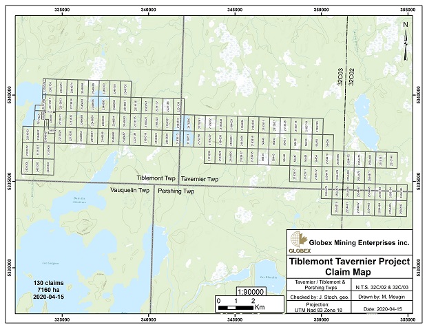
The Tavernier-Tiblemont property consists of 130 cells totaling 7,160 ha extending east-west over 18 km in eastern Tiblemont and western Tavernier townships. The property is located 16 km east of Highway 113, which joins Senneterre (25 km to the north) with Val d’Or (45 km to the west-southwest). The majority of the cells in Tavernier Township were acquired by staking by Globex in 2005 and the land position was expanded during 2010, 2011, 2012 and 2020 into Tiblemont and Pershing Townships to constitute the current holdings.
This property is wholly owned by Globex and is not subject to royalties or agreements except for a 13 claim internal block in the centre of the property which is subject to a 2.5% Gross Metal Royalty to Adventure Gold Inc. and 3 claims subject to 1% NSR with $100,000 buy back of 0.5%.
Access to the property is via gravel logging roads and secondary dirt roads originating from Senneterre. Geophysical grids can be reached by ATV. Topography in the area is subdued to gently rolling with local relief of no more than 25 m. Muskeg swamp dominates the central and eastern portions of the property which render ground access challenging both summer and winter.
History
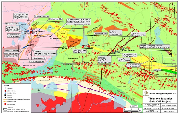
Exploration dates back to the late 1960’s when Anaconda outlined a zone of precious metal bearing volcanogenic disseminated and stringer sulphide mineralization referred to as the Anaconda zone, located by follow-up drilling of airborne/ground geophysical anomalies. Assessment records for core assays are incomplete. Records suggest the best available base metal assay of massive sulphides graded 4.03% Cu, 9.13% Zn, 585.7 gpt Ag and 26.4 gpt Au/0.3 m (hole 615). Historic gold/silver sulphide intercepts include 1.4 gpt Au, 86 gpt Ag/3 m and 1.4 gpt Au, 10 gpt Ag/1.5 m and elsewhere, near the east shore of St. Vincent Lake, an historic sulphide gold intercept of 27.0 gpt Au/0.62 m (hole 614) is found in the same area where a boulder of black chlorite with chalcopyrite stringers is also reported to have been found.
The reader is referred to Globex’s 2013 Annual Information Form (AIF) filed on SEDAR (www.sedar.com) and on Globex’s website (www.globexmining.com) for more details concerning the history of exploration work on the Tiblemont-Tavernier property for the period from 1960 to 2010.
Geological Setting and Mineralization
The reader is referred to the 2011 Annual Information Form which is available on (www.sedar.com) and the Corporation’s website (www.globexmining.com) for further details regarding the regional and local geological settings of the project area and detailed descriptions of mineralization reported from historic exploration work.
Exploration and Development
In 2005, Globex commissioned a 311 line km helicopter-borne magnetic/ electromagnetic survey at 100 metre line spacing, over the Tavernier (Eastern) portion of the property. During the period 2009 to 2011, Globex carried out prospecting/mapping and systematic IP coverage totaling 191 line km beginning with frequency domain survey work (east end of claims) and continuing with wide array time domain IP in the central portion of the property. Selective ground magnetic and horizontal loop EM survey work in areas of known VMS mineralization was also included to compliment the large ground survey database.
In 2012, an overall compilation and re-interpretation of the historic geological and geophysical data was completed by Globex. In October, a total of 551 line km of close spaced, high-resolution aeromagnetic/VLF surveying were completed by contractor Terraquest Ltd. over the central and western portions of the property to compliment the coverage from Globex’s 2005 eastern airborne survey. Detailed mapping and sampling of a number of the gold zones (Maufort, Pine Lake, Realore and others) were carried out by Globex during the summer, confirming the gold mineralization. Grab samples returned; 13.5 gpt Au; 4.9 gpt Au with 0.14% Cu at the Realore zone; and 13.3 gpt Au; 36.4 gpt Au with 14 gpt Ag at the Pine Lake zone while gathering firsthand information on the styles of vein systems associated with these historic showings.
In January, 2013, in-fill ground geophysics (magnetic & electromagnetic surveys) over Lake St. Vincent were completed and the interpretation and final imaging of Terraquest’s airborne magnetic and VLF information was integrated with ground geophysical results to enable Globex to propose an initial drill program targeting polymetallic, gold bearing VMS and orogenic quartz lode targets.
The 2013 diamond drill program included 3 holes testing VMS targets totaling 1,182 m and 9 holes testing gold targets totaling 2,808 m. Drill tests of VMS targets defined by geophysical anomalies were explained by the presence of conductive barren sulphides or graphite. No significant base or precious metal mineralization was identified in the VMS targets. Interesting gold intercepts were generated in drilling the mineralized NNE trending Maufort Megashear in the western portion of the property. Here, Globex’s wide spaced (100-150 m) drilling of auriferous quartz veins in shear structures cutting granodiorite returned (from South to North) along 300 m strike length, the following gold intercepts; 23.6 gpt Au/1.0 m (hole TIB-13-11); 9.7 gpt Au/1.0 m, 4.29 gpt Au/1.0 m (hole TIB-13-3); 2.46 gpt Au/1.0 m, 19.6 gpt Au/1.5 m, 3.9 gpt Au/1.0 m (hole TIB-13-12). A deeper hole undercutting TIB-13-12 returned a substantial intersection of 4.78 gpt Au/8.8 m including 6.15 gpt Au/4.3 m (hole TIB-13-13). This wide gold intercept occurs at a vertical depth of 225 m and constitutes the deepest gold intercept obtained at the property and remains fully open to depth and along strike in both directions within this gold zone.
Exploration work in 2014 included a 4 hole, 735 m drill program. Two holes tested the southern extension of the Maufort Megashear zone and other two holes tested the lateral extension of the Blair showing. The drilling at these two prospects did not return any significant gold values. Future efforts will be concentrated in areas where 2013 drilling by Globex returned important intersections of gold grade and width.
|