|
Lyndhurst Mine - Partial JV on Mining Concession - Polymetallic
Destor & Poularies Townships, Quebec (NTS 32D10 - 11)
Updated October 2021
Property Description and Location
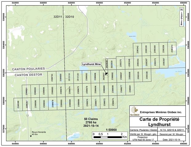
The Lyndhurst property consists of 50 claims totalling 2,795 ha straddling the township line of Poularies to the north and Destor to the south. The property is located 35 km north of Rouyn-Noranda, Quebec immediately east of Highway 101 which connects Rouyn-Noranda with La Sarre. The area is characterized by low relief with slow running streams and small lakes and ponds.
These claims are wholly owned by Globex and are not subject to any underlying royalties or third party interests except for the Lyndhurst former mining concession which is subject to a 1.5% NSR to certain original property vendors. A portion of the former mining concession is currently joint ventured with local entrepreneur Agrégat-R-N inc.
History
The Lyndhurst property has been explored intermittently by various exploration companies since the late 1920’s. In 1955, Lyndhurst Mining Co. Ltd. sank a 215 m shaft, carried out some development on five levels and completed surface and underground exploration diamond drilling. Exploration work is reported by Lyndhurst (ref Canadian Mines Handbook 1957) to have defined 372,143 tons of mineralized material in two sulphide lenses at a grade of 1.95% Cu. It was reported in the following year that 156,362 tons of material were shipped before operations ceased. These historical resource and production figures should not be relied upon as they were prepared before the application of NI 43-101 or to Canadian Institute of Mining and Metallurgy (CIM) Definition Standards for Mineral Resources & Mineral Reserves.
Following this limited mining activity, surface exploration, including trenching and shallow drilling, were carried out by various companies prior to 1988. In 1988, Minnova Inc. completed an airborne EM (INPUT) survey and follow-up with DEEP-EM ground electromagnetic surveys, geological and lithogeochemical sampling, stripping and some diamond drilling.
From 1991 to 1993, Noranda Exploration carried out geological mapping, outcrop stripping, induced polarization and horizontal-loop electromagnetic surveys and diamond drilling, without encountering any significant new VMS mineralization. The property remained dormant until 1997.
Geological Setting
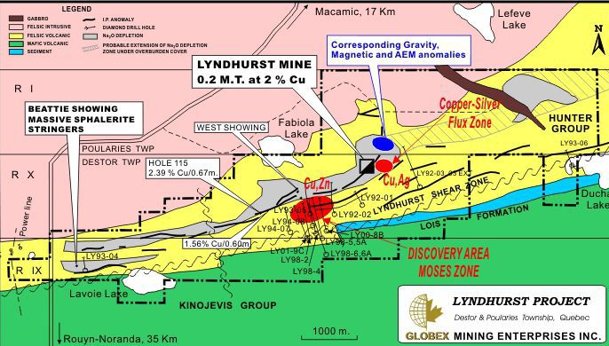
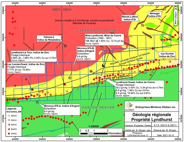
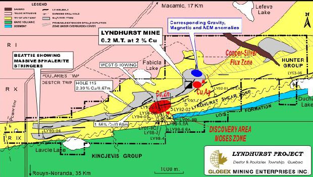
The property is underlain by the Archean Hunter and Kinojévis volcanic groups which are composed mainly of felsic and mafic volcanic rocks. This volcanic belt is bounded to the north by the large Poularies and Palmarolle granitic batholiths which define the regional structure known as the Lac Abitibi Antiform. The regional east-trending Lyndhurst Shear Zone extends along the southern half of the property and defines the regional contact between the Hunter and Kinojévis volcanic groups. A large mineralized alteration zone has been followed down-plunge from the Lyndhurst mine to the west and is open at depth.
Exploration and Development
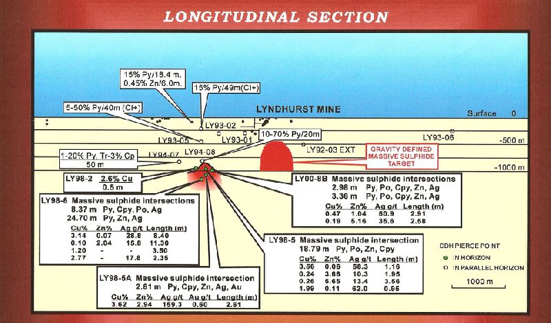
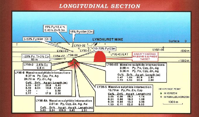
From 1997 to 2000 the property was optioned by Vancouver junior Amblin Resources Inc. who, under the operatorship of Globex, completed an airborne magnetic/electromagnetic survey and a subsequent ground gravity survey. A gravity anomaly west of the Lyndhurst deposit was drilled at a shallow depth in 1998 and complimentary borehole geophysics identified further anomalies warranting more drilling. Six additional drill holes (LY-98-01 to 98-05 and 98-05a) lead to the discovery of the deep seated (1,150 m from surface) volcanogenic massive sulphide Moses Zone. This zone is identified from the initial holes as mostly narrow Cu/Zn/Ag mineralization including 3.6% Cu, 58.3 gpt Ag/1.2 m, 3.7% Zn/1.9 m and 5.7% Zn/3.6 m (discovery hole LY-98-05); 3.6% Cu, 2.9% Zn, 159.3 gpt Ag/2.6 m (hole LY-98-05A, a 110 m undercut to hole LY-98-05). Two subsequent deeper holes (LY-98-06 and 06a) encountered wider massive sulphide intercepts grading 3.9% Cu, 34.9 gpt Ag/6.4 m (LY-98-06a) and 2.6% Zn, 13.7 gpt Ag/8.4 m (LY-98-06a). Hole LY-98-06, a 90 m undercut to hole LY-98-05A suggests improvement in thickness of the sulphide lenses with depth.
In 2000, Globex completed additional drilling in the Moses Zone area which returned two narrow zinc mineralization zones in massive sulphides, including 6.8% Zn, 33.0 gpt Ag/0.5 m and 5.2% Zn, 35.6 gpt Ag/2.9 m (hole L00-8B). Shallow drilling in 2001 and 2004 by Globex in the No.1 Zone (250.m east of the original Lyndhurst deposit), intersected mostly narrow Cu/Zn/Ag/Au values with the better widths in the No.1 Zone including 1.36% Cu, 26.5 gpt Ag/7.38 m in hole L-04-02 at a vertical depth of 35 m in a brecciated high silica sulphide stringer zone hosted in rhyolite within a larger envelope of mineralization grading 0.83% Cu, 16.42 gpt Ag/17.2 m. Continued drilling of the shallow No. 1 Zone copper mineralization in 2007 (21 holes totaling 2,000 m) did not prove sufficiently encouraging to pursue the concept of potential open pit extraction. Between 2008 and 2010, new deep penetrating geophysical orientation tests were undertaken including; IP, magneto-tellurics and an airborne gravity survey in the vicinity of the Lyndhurst deposit, the #1 Copper-Silica Zone and Moses Zone. These surveys focused an 8 hole, relatively shallow drill program of 2,942 m which did not encounter any significant new VMS mineralization.
In 2011, a 56.5 km dipole-dipole IP survey at 100 m line separation was completed over the western half of the property, covering approximately 4.5 km of ground westward along strike from the known Lyndhurst/Moses Zone VMS occurrences. This survey work was successful in tracing several known mineralized trends including the historic Beattie zinc stringer zone, where selective historic grab samples assayed best values of 31.6% Zn, 3.0% Pb, 200 gpt Ag; 8.8% Zn, 33 gpt Ag; and 6.6% Zn, 31 gpt Ag. The wide array IP suggested geophysical continuation to depth (>200 m) of the disseminated and stringer sulphides found at surface at both the main Beattie Zinc showing and Beattie North zinc stinger zone, identifying priority drill targets.
In 2012, a single deep, 997 m drill hole (LYN-12-01) was completed to test for the presence of volcanogenic massive sulphides down dip from the surface rhyolite-hosted disseminated and stringer sphalerite zones of the Beattie Zinc Showing and Beattie North zinc stringer zone at vertical depths of 325 m and 650 m respectively. No significant zones of copper-/zinc-bearing massive sulphides were encountered although intermittent and wide (75-100 m core length) haloes of weak chalcopyrite or sphalerite, pyrite-quartz stringers and locally intense black chlorite alteration were intersected at both anticipated down dip projections of these surface occurrences. A borehole geophysical survey in Lyn-12-01, while responding to the multiple narrow Cpy stringers, failed to detect any off-hole conductor suggestive of the presence of a larger conductive massive sulphide lens within an estimated 100 m radius of the drill hole.
In 2013 a review of all available exploration data along with targeted surface mapping were undertaken and it was concluded that the property scale exploration potential for blind, potentially large VMS deposits within the extensive hydrothermally altered Lyndhurst felsic volcanic complex lies below a minimum vertical depth of 800 m. An experimental ambient frequency surface geophysical survey was conducted over the deep seated Moses sulphide zone however this test failed to definitively demonstrate its ability to detect the presence of deeply buried conductive sulphides.
In the light of these findings, it is concluded that any meaningful further deep exploration work would require a focus on stratigraphic drilling. Several deep targets have yet to be fully assessed.
In 2014, work to re-evaluate deep stratigraphic drilling at the Moses VMS zone and the under-explored eastern sector of the property continued. Rehabilitation work in connection with the exploration program on the Lyndhurst property continued at the old Lyndhurst mine site began in 2014 and continued through 2015 with re-vegetation of closed areas. Surface water tests are taken twice a year to monitor local water quality at the site.
In 2015, sample rejects from the 2009 channel sampling program at the Lyndhurst Mine zone Zone 1 were re-submitted for litho-geochemical analysis with a view to determining the value of near surface material as a potential value-added smelter flux. Results identified a low grade envelope 20 m thick and 40 m in length open in both NE-SW directions grading 0.73% Cu, 10.9 gpt Ag, 80.3% SiO2. A higher grade 2.06% Cu, 26.9 gpt Ag and 78.6% SiO2 zone, 5 m thick and 30 m in length is located inside the envelope.
A new technology, deep-penetrating airborne geophysical survey covering the Lyndhurst mine and the Moses zone was also performed and preliminary results present areas of interest to be reviewed in 2016 once a full interpretation has been completed.
|